Design & Story of The Western Reserve Products
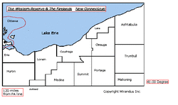
The design is composed of the original boundaries of "The Western Reserve" ,"New Connecticut" or the "Connecticut Western Reserve", which were 120 miles west of the Pennsylvania state line, south to 41 degrees, 00 minutes, (roughly 3 miles south of Route 224) and north to Lake Erie.
Within this area lie fourteen counties.
Lying completely in it are nine counties:
Trumbull, Ashtabula, Lake, Geauga, Portage, Cuyahoga, Lorain, Medina & Huron.
Partially within it are five counties:
North of the 41st degree - Mahoning, Summit & Ashland. East of the 120 mile length - Ottawa & Erie.
The boundaries on the products are based on the current county and township boundaries.
The Colors are:
Blue to signify Lake Erie, the rivers, lakes & canals. The lake plus the natural & manmade waterways are very important to the history of the region.
Red to signify the sugar maples, the original Native American Indians & the State of Ohio. The Sugar Maple is the "Symbolic Tree" of the region.
Black to signify the Black Squirrel, agriculture (soil) and industry. The Black Squirrel is the "Symbolic Animal" of the region.
Copyright Mirandus, Inc. © http://westernreserve.weebly.com [email protected]
